| Title | Colorado-Yuma-Smothers | ||||||||||||||||||||||
| Site Development Status | Available | ||||||||||||||||||||||
| Lease or Sale | Lease Only | ||||||||||||||||||||||
| Site Available (Acres) | 748.0 | ||||||||||||||||||||||
| Lease Rate, Year 1 | $375 | Annual Escalator | 2% | ||||||||||||||||||||
| Sales Price | Per Acre or Site | ||||||||||||||||||||||
| Summary | Property Parcels
Property Characteristics [ 753.6 ] Number of acres available for lease or sale? James [ yes ] Is the property immediately contiguous to a substation? [ NK ] What is the maximum transmission capacity of the line (ampacity)? [ 69KV ] What is the maximum voltage of the line? [ NO ] Does the property require extensive grading? [ LOW ] Low, Medium or High Local Utility Rates & Costs [ $2,500 ] What is the comparable price for this kind of land in the area? Local Loads: 130 MW Summer 30 MW Winter Highline, Morgan County REA, KC Electric Association. System engineer indicates that the 69KV capacity is limited due to low loads in the winter. | ||||||||||||||||||||||
| Latitude | |||||||||||||||||||||||
| Longitude | |||||||||||||||||||||||
| Infrastructure Mapping Information, Open Doors | https://www.arcgis.com/home/webmap/viewer.html?webmap=f928f314504444d8a2d459fc40d2cc07&find=39.71583559,-102.4628153 | ||||||||||||||||||||||
| Site Image | 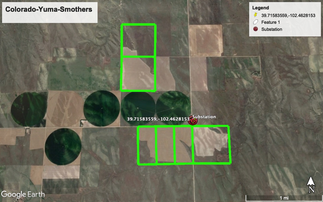 | ||||||||||||||||||||||
| KMZ File | Colorado-Yuma-Smothers.kmz | ||||||||||||||||||||||
| Term Sheet | https://docs.google.com/document/d/e/2PACX-1vTOputlRIbFNE9wNL2tVW5P3pJUQoBJYHckfFvrM8AM6OH2TKoGPHGsRPQtgLOFitysqukbA_tYzagA/pub | ||||||||||||||||||||||
| County | Yuma | ||||||||||||||||||||||
| State | Colorado | ||||||||||||||||||||||
| Legal Owner | Kirk Smothers | DO NOT CONTACT | |||||||||||||||||||||
For Information | Lane Sharman +1-858-342-1415 lane.sharman@opendoors.com | ||||||||||||||||||||||
| Energy Community? | |||||||||||||||||||||||
| Assignment | Lane Sharman | ||||||||||||||||||||||
| Listing URL | https://www.ragic.com/ozquantum/real-estate/6/8?embed&hidetop&embedEntry&rmlc=dyidWsv5a8OGr20221212183906ozquantum%2Freal-estate%2F6 | ||||||||||||||||||||||
| Local Utility | Y-W Electric Association | ||||||||||||||||||||||
| Interconnection Brief | None provided. | ||||||||||||||||||||||
| Owner & Site Brief | Owner is motivated to secure an energy development lease. | ||||||||||||||||||||||
| Development Brief | Yuma County is an up and coming resource for wind and solar development. This property is ideally suited for either wind or solar. Tri-State is motivated to move off of its coal resources. The line voltage is 69KV, not 115KV as documented in the mapping resource. | ||||||||||||||||||||||
| Site Analytics | co_80m.jpg | ||||||||||||||||||||||
| Listing Sequence Number | 8 | ||||||||||||||||||||||
Site Characteristics | |||||||||||||||||||||||
| Type | Notes | Map URL | Image | File | Characteristic SeqNbr | ||||||||||||||||||
| Substation ID | 8/12 Interview with Tony McAfferty, Y-W Engineer Tony confirmed that the substation was a 69KV substation, not 115KV. Tony will deliver the line ampacity. He confirms that the lines are owned by Y-W, not Tri-State. Trent Loutensock was also interviewed and he asserted Tri-State was the line owner before referring me to Tony. | https://www.arcgis.com/home/webmap/viewer.html?webmap=f928f314504444d8a2d459fc40d2cc07&find=39.71583559,-102.4628153 | 00514 | ||||||||||||||||||||